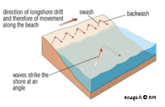
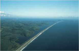
Chesil Beach is 18 miles long and contains 180 millions pebbles. It is located on the Dorset coast and was formed by longshore drift. Longshore Drift is the process whereby sediment is moved along a beach. The direction of the prevailing wind and in turn the waves dictates the direction the sediment travels. The swash carries the sediment up the beach in the same direction the waves are going moving the sediment along the beach. When the water flows back into the sea in the Backwash it takes some sediment with it which is then caught in the swash again and moved along the beach. This is process is called Longshore Drift and is how Chesil Beach was formed.
On Chesil Beach the size of the pebbles varies from end to end as proof of the erosion that has taken place on the pebbles as longshore drift has moved them down the coast, with large pebbles at the Portland end and smaller ones at Abbotsbury. How Chesil Beach was actually formed remains a hotly disputed argument, the most common of which states that it was driven on shore by rising sea levels at the end of last ice age. Since then Longshore Drift has moved material along the beach eroding it and making the pebbles smaller as you progress down the beach.
When Chesil Beach reached the headland at Weymouth it would have formed a spit out into the sea reaching towards the Isle of Portland. Due to longshore drift moving material West to East it is also likely that a spit was beginning to form off the North shore of Portland, this spit would have stretched out and met Chesil Beach to form a tombola connecting the Isle of Portland to the mainland.
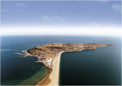
Here you can see the tombola that connects the Isle of Portland to the mainland.
Did you know that Chesil Beach was used to test the bouncing bomb for the famous Dambusters Raid of the Second World War!!
Key words:
Prevailing winds Swash Backwash Longshore Drift Bar Spit Tombola
Time to test yourself...
Home
Fleet Lagoon
The Isle of Portland
Lulworth Cove
Christchurch Harbour
Bournemouth and Barton-on-Sea
